Life in Area C…..
May 27, 2010Oslo Accords and the Creation of “Area C”
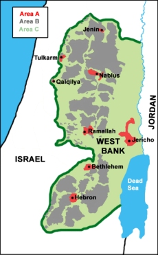
After the 1993 Oslo Accords, the final status of the West Bank was deemed to be subject to “upcoming” agreements between Israeli and Palestinian leadership. In the meantime, the authority of the West Bank was divided between Israeli and Palestinian through the creation of three different types of “areas”—A, B, and C.
Area A, which makes up 17% of the land in the West Bank, and is home to 55% of West Bank Palestinians, was put under the control of the Palestinian Authority. Area B, 59% of the land and 41% of the Palestinians, was put under joint Israeli-Palestinian control—civil authority for the PA and security for the Israelis. Area C makes up 59% of the land and 4% of the Palestinians, is under full Israeli control. There are 150,000 Palestinians living in Area C and 400,000 Jewish settlers living in 120 official settlements and 100 illegal outposts.
Area C contains all of the Israeli settlements, settler roads, security buffer zones, strategic areas, and Israeli military bases and zones. The places in the West Bank that make up most of the Area C are the Jordan Valley, East Jerusalem, and the Judean desert.
While the majority of the Palestinian population lives in Area A and B, much of the land around these Palestinian built-up areas, villages, and cities is defined as Area C. Therefore, many Palestinian communities have lost farmland—vital to the economy of many villages, and the land that their communities would naturally expand into as the population increases. The Israeli military retains full control of the land, roads, water, airspace, security and borders for the land in Area C.
Ethnic Cleansing Via Bureaucracy
Life is made almost impossible for any Palestinians living in or near Area C because of the complex bureaucratic system the Israelis set up for that very reason. Palestinians in Area C need a permit from the Israelis in order to repair their own homes and infrastructure, to build new homes on their own land, to access water, and to access their own farmland. Needless to say, these permits are not given out in a timely manner, if at all.
The Palestinians in the Jordan Valley, especially the bedouin communities, have been facing the most intense Israeli policies aimed at cleansing the area of Palestinians so that Israel can take over full control of the resources there. Another Israeli aim in taking over the Jordan Valley (30% of the West Bank territory) is to unilaterally establish an eastern border of the West Bank that would isolated it inside Israel–without any borders leading to other, more friendly countries.
Since 1967, Israel has been carrying out a “creeping” ethnic cleansing on the residents of the Jordan valley through its permit system and other policies–taking the Palestinian population down from 320,000 to only 56,000 today.
One example of the irrationality of the permit system is in Jiftlik, a village in the Jordan Valley—which is almost entirely Area C. In Jiftlik, they have had to put electricity poles in concrete blocks which are placed above the ground instead of digging a hole for them because according to the Israelis, digging holes more than 40 cm in the ground is illegal.
Sometimes you will see corrugated tin roofs camouflaged with plastic covering because building a roof out of metal counts as “building a second storey” in the Israeli system. And of course, they would need an impossible-to-get permit for that.
“Breathing is the only thing we don’t need a permit for—yet!” Said Abed Kasab, one of the residents of the village.
Economic Damage in Area C
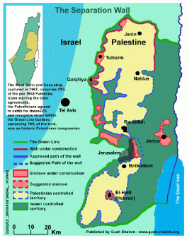
The economies of the villages and cities in or near Area C have been very negatively affected by the restrictions placed on them. It is the same for Palestinians living in communities near the Separation Wall—which has isolated them from other cities making economic trade and travel to access services such as health care almost impossible. By 2008, over 3,000 businesses were forced to close in the West Bank because of the Separation Wall’s construction through or near their communities.
Qalqilia and Tulkarem
In Qalqilia, the Separation Wall has completely surrounded the city, leaving just one Israeli-controlled gate to allow any people and goods in or out. The isolation of Tulkarem due to settlement blocs and the Wall has also been significant. 37% of the West Bank agricultural land is found in the Jenin, Tulkarem, and Qalqilia governorates.
The damage done to the land in these areas by the Separation Wall is severe. At the beginning of its construction, 83,000 olive and other fruit trees, 615 dunams of irrigated land, 37 km of water networks, and 15 km of agricultural roads were destroyed systematically.
In addition, 238,350 dunams of land were isolated between the Green Line and the Separation wall, 57% of which was cultivated and is now almost inaccessible to the Palestinian farmers. The worst effect of this land confiscation is poverty—by isolation and fragmentation.
Nablus
Economically, Nablus has been under siege since the beginning of the Second Intifada. Huwwara checkpoint, just outside the city of Nablus, was the only way to get in or out of the city. This made trade and business almost impossible for years, strangling the economy.
To make matters worse, the Israeli military would arbitrarily close the checkpoint for different amounts of time—causing normal life to stop in Nablus. When Huwwara checkpoint is operating “normally” the line of cars waiting to leave or enter Nablus can be kilometers long, and the people must wait for hours.
Hebron
In Hebron, the Israeli settlers took over apartments right in the middle of the city. This area is now referred to as H2—and has caused extreme damage to the economy of Hebron because it is located in the central market of the city. Here, around 800 Jewish settlers live among 30,000 Palestinians.
The settlers’ presence has been slowly choking the economy of Hebron. The settlers are protected by the Israeli military—who have set up checkpoints throughout the marketplace to ensure the safety and freedom of movement for the settlers while denying both to the Palestinian residents.
More than half of the shops in the central marketplace have been forcibly shut down, or gone out of business due to the presence of settlers, military, and checkpoints in the market. Palestinian shop owners have to put chain link fencing above the alleyways outside their shops because the settlers, who have taken over the upstairs apartments, routinely throw garbage, glass bottles, and even sewage water down on the shops and people below.
Violent Effects of Settlements on Area C Palestinians
Hebron
The settlers in Hebron are the most violent in the West Bank, they systematically attack their Palestinian neighbors with complete impunity. Of course, they are allowed to carry automatic rifles and are protected by the IDF, so they can beat any Palestinian they want, or rip the veil off of any woman with no consequences.
South Hebron Hills
In the South Hebron hills, which are in the middle of Area C, the settlers constantly attack the Palestinian villagers. Sometimes they send dogs on the Palestinians, other times settlers wearing hoods or masks wait for the school children or shepherds to walk home where they stone them, beat them, or steal from them.
Recently, a 6 year old child who was grazing his sheep in an area isolated by the barrier near the settlement of Shani, was physically assaulted by a settler. Also, the settlers destroy olive and fruit trees as well as burning entire agricultural fields.
Nablus
Nablus is surrounded by settlements—which are built on the tops of the hills around the city. These settlers are constantly attacking the Palestinians in villages near settlements. Recently, West Bank settlers have been following a “Price Tag” policy in response to international pressure on Israel to freeze settlement construction and dismantle illegal outposts.
This policy requires that for every outpost or building in a settlement demolished, the settlers will organize an attack on neighboring Palestinian communities. This policy has been very obvious in the Nablus area.
Recently, Israeli settlers from the Yitzhar settlement entered Huwwara village near Nablus and vandalized the municipal park—damaging the park lights, sound amplifiers, children’s toys, and olive trees near the park. They also threw stones at a nearby house, breaking several windows.
In addition, on May 4th, settlers set fire to a mosque in Lubban Al Sharqiyya—one day after the Israeli civil administration demolished 5 structures under construction in the settlement of Shave Shomron; a clear Price Tag policy attack. This was the 3rd act of vandalism targeting mosques reported in the northern West Bank since December 2009.
Salfeet
In Salfeet, a city which is surrounded by 17 settlements (built on land confiscated from the city and villages around it), the settlers prefer to send wild boars down on the Palestinians below. These wild boars are huge and very dangerous—in addition to destroying farmland and agriculture, they could also seriously injure or kill anyone who gets in their path.
Environmental Damage Caused by Settlements
What’s more, the surrounding settlements are causing a great deal of environmental damage in the West Bank. Israeli factories that are not within the standards of environmental and health protection of Israel move to the West Bank to bypass these regulations.
Near Salfeet, settlements and factories are causing major environmental damage. They dump chemical waste from factories onto Palestinian fields—which contaminates the produce. The settlers also drain their sewage water into nearby villages and land—causing severe health effects on the people.
Water War
Water availability is another complex issue in Area C. The wells in Area A & B are not completely under Palestinian control, and the ones located in Area C are not available at all to Palestinians. Israeli use of West Bank water is 7 times what the Palestinians use. Area C contains 280 out of 597 wells, and of these only 51 are owned by Israel.
Yet, somehow, Israel’s annual yield of water equates to over 66% of the total water yields in Area C. This is why the Israeli settlements have green grass in every yard, swimming pools, etc…while in Palestinians cities and villages, people can go weeks without water in their homes–especially now, during the summer.


its more then great its really amazing .
Very educational. The maps make a real difference in helping to visualize what’s happening. But seeing is believing. Good job, Renee!
Interesting. So this is the only conflict in the world with only one side, right? This would look much more trustworthy if there was at least an attempt to show two sides of the story
Thanks but this is not a news website, tis a blog of my experiences living in palestine. Sorry I couldnt make Israel’s occupation look “good” 😉